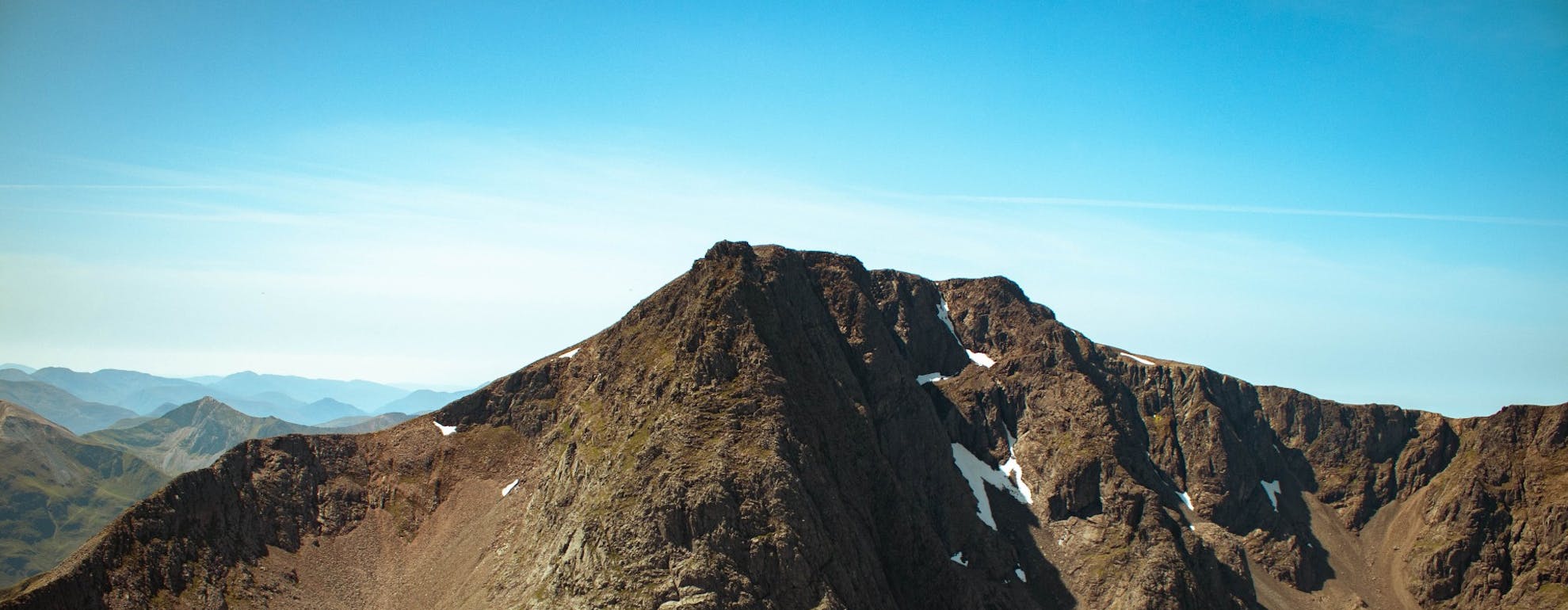
UK's Best Walks and Hikes Part 4: Ben Nevis
In part 4 of our series featuring the UK’s best walks and hikes, our SportsShoes Hiking ambassador, Gerda Lejasmeiere, tells us about her latest adventure on Ben Nevis, the UK’s highest peak.
ㅤ
BEN NEVIS VIA CMD ARÊTE (CÀRN MÒR DEARG)
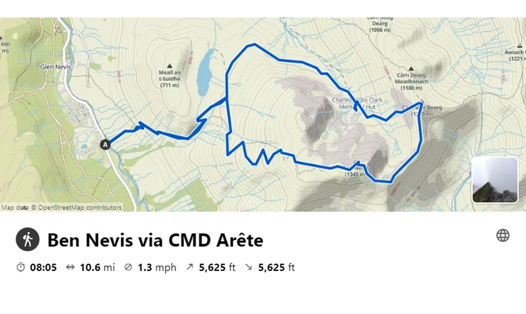
VISIT KOMOOT FOR A ROUTE MAP & MORE INFORMATION
ㅤ
When planning a recent trip to Scotland, my hiking group and I were desperately keen to hike to the top of Ben Nevis - because how can you not?! It’s the highest peak in the UK after all! Whilst doing some research, I knew my friends would want to go the most fun way up. So, I came across an article about CMD Arête and I knew that this was the only route for us. And oh my, it did not disappoint.
See, if I’m ever left to plan a route you have to expect that I will somehow find the most difficult and possibly the least walked route, as I love an adventure and a challenge. And quite possibly on some of my planned routes we might occasionally lose the path too!
Even at the start of the route there are warning signs to be careful and so there should be as, as much fun hiking up mountains and scrambling across rock giants is, it is also very serious and you should be prepared for the dangers ahead.
The path to the CMD Arête starts on the route that most people take, so it may be quite busy on the path. The beginning climb is steep and constant gradient, but provides many rewarding views for you to enjoy.
ㅤ
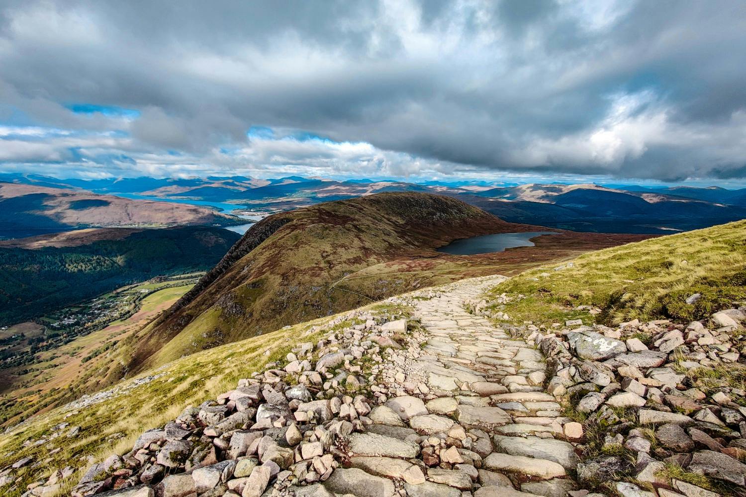
Pictured: The view of Lochan Meall an t-Suidhe. Image courtesy of Migle Siauciulyte, Unsplash.
ㅤ
Once you come across a slightly flatter route with a more gradual ascent, the path will split just after a tarn. Most people will head up right, but our route took us left, where we saw no one else heading.
This path to the left leads down into a valley and is quite easy as it is going downhill and honestly it is quite a nice break where you can catch your breath after the incline at the start. As well as a nice chance to take it easy before you have to start climbing again.
Following this path, you will come across a hut at the end of the valley. This is a rescue post – the Charles Inglis Clark Memorial Hut. When we visited the hut was locked and no one was found inside, but this was a very lovely spot to have a little break to refuel for the rest of the hike. The views, as I’m repeating myself, were stunning! There is a makeshift fresh water stream that comes from the mountains where you can refill your bottles. However, as much as we didn’t have any problems drinking this water, please hold yourself responsible to judge the water source as I cannot guarantee that it is safe. You will also find a telephone for mountain rescue there, let’s hope you will not need to use it, but it is there if you do need it. We also happened to have some signal there too so it’s a great spot to let everyone know that you are safe!
Once you have had a rest and are ready to carry on you will need to pass the hut and follow the path further. When looking at OS maps there wasn’t really a path after the hut, however when creating the route, it did let me go in this direction so we just headed up the suggested way over the rocks without a clear path. This is where the route gets tough and if you do go this way you will have to climb up the face of the mountain over very rocky terrain, that can be quite dangerous and I would suggest to take your time to make sure that the rocks you’re choosing to step on and hold on to are stable, as quite a lot of them were loose when we attempted it.
ㅤ
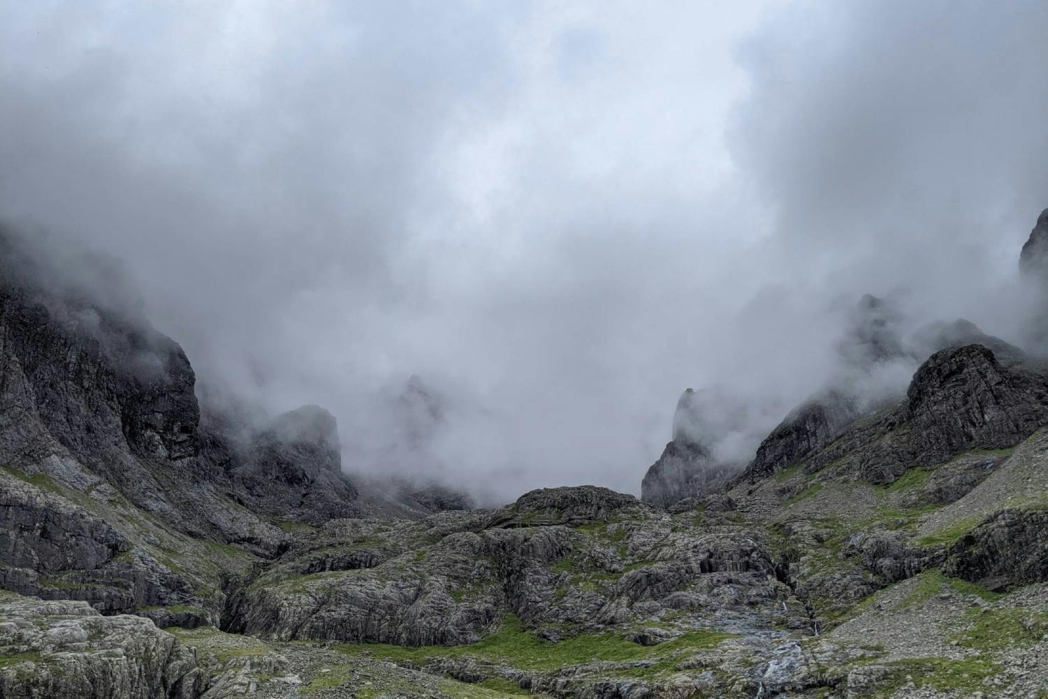
Image courtesy of Gerda Lejasmeiere
ㅤ
The trail will lead straight up to Càrn Mòr Dearg (1220m) summit. This will be a tough climb and to be honest, whilst we were scrambling up the rocks to reach it, I thought to myself that the person who I took inspiration from for this particular route must be laughing every time someone climbs up it. Ha! That’s how tough it was as there was no route, just rocks everywhere. Quite a lot of ascent will be covered during this climb.
Please be warned: : this route is not suitable for everyone, only for those with a real taste for adventure, a head for heights and confidence on exposed scrambles, as steady feet and sure-footedness are required when tackling this route! Do not attempt this route if you have any doubts or concerns about your ability and safety.
Once you do get to the top, the famous Càrn Mòr Dearg Arête will be to your right. By this point the weather had turned and we couldn’t really see much of anything, as we were in the clouds. It still looked very cool that the ridge was half covered by clouds and half in view. In fact, it was quite surreal really.
The moment we stepped onto the ridge it started raining, which made the scramble more dangerous as the rocks became quite slippy. We had to be very mindful of our steps and even with that we managed to pass a group of fellow hikers who were just as mad as us by attempting this route during the rain. However, once you’ve come this far it would be quite a shame to turn around really. And we didn’t even think of doing that.
*WARNING! An important piece of advice - if the weather is mild & dry and you are sure-footed, then feel free to challenge yourself on this scramble. However, if it is raining - I strongly advise you to skip this section, as the ridge is very slippery and very dangerous when wet!
ㅤ
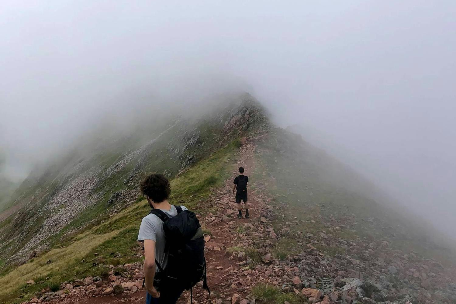
Image courtesy of Gerda Lejasmeiere
ㅤ
At this point all you really have to do is carry on forwards, you may see the path at times and at times it may disappear under your feet with no clear direction. This is where having the route on my watch for navigation was great! We kept going the direction the watch suggested and kept climbing on up. As a back-up, always carry a compass and map with you, but most importantly learn how to use it!
ㅤ
Check out our Beginners Guide to Hiking and Trail Running Navigation here
ㅤ
This seemed like a very long scramble up! With nearly no visibility and soaked in rain we kept our spirits high and kept on pushing.
By the time we reached the summit of Ben Nevis (1345m) even the waterproofs we were wearing couldn’t save us from the rain. You have to always remember that everything is only waterproof up until a certain point. If you’re out in the rain for a few hours your waterproof jacket will eventually give in to the rain. If I ever find one that keeps me dry in such extremes then I will most definitely share!
As we got to the top, we could see quite a lot of people that had come up the other way. Even in this weather there were still a surprising amount of people. (Nothing to compare to climbing Snowdon though!) No queuing really. Only a couple of minutes of wait at the most to get a picture at the trig point. People were mostly interested in seeking shelter in the tiny hut at the top, which could fit up to 6 people, I believe.
It took us 6 hours to get up to the trig point. Which I think is quite good, especially after discussing victories of climbing Ben Nevis with other hikers on the top, as for most of them coming up the regular route took 5-6 hours.
ㅤ
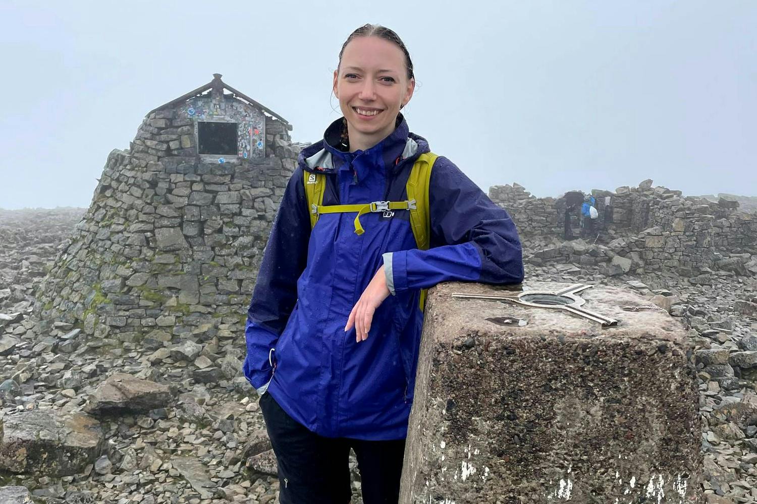
Image courtesy of Gerda Lejasmeiere
ㅤ
Even with being cold, wet and quite tired at this point we were filled with happy emotions. I remember catching myself thinking of why I’m doing this to myself as there are so many other things I could be doing with my Sunday. But hey-ho, life is for living and for some reason I have found happiness and bliss in being outdoors, climbing and scrambling over rocks no matter the weather.
On the way down we took the so-called tourist route and in our usual manner we broke into the occasional jog, as for some reason we find running down mountains easier than walking down them. This might be due to lesser impact on the joints and going with gravity rather than reacting against it. But I really couldn’t say. It took us 2 hours to get back down to the car park just behind the Glen Nevis Youth Hostel (A free car park, but only for about 4-5 cars. It does seem however that not everyone knows that it’s there, as there was still room for more cars when we parked. There is also a visitor centre nearby that has facilities but I think this car park is closer to the start of the route that we chose).
I would 100% recommend doing this route as it is stunning and very challenging and I would also say that most people wouldn’t go this way, even if choosing to tackle the Càrn Mòr Dearg Arête as we didn’t see anyone really, except until we reached Càrn Mòr Dearg. The most common way is to carry on once you go left to split and not head down into the valley but carry on to get to the top of Càrn Mòr Dearg around the valley, with two other peaks on the way. I cannot comment on how difficult the route is in comparison to this one, but it does seem more favourable for most people that choose the tougher route. I think that this was the most difficult route that I have done so far. I do recommend it though as it was quite the adventure. If I was to do this again, I would try and skip the valley to head around it instead. I have no regrets for taking this path, but doing something else next time would probably be my choice.
In regards to fear factor, I did not find this route to be too alarming, just mostly physically difficult. And compared to climbing Snowdon via Crib Goch I would say that it was definitely more bone chilling. But maybe this is due to the lack of visibility we had on the Ben Nevis climb. Who knows? I’ll let you know next time I go! The first time I climbed, or even walked to the top of Snowdon, it was on the Llanberis path which is definitely the easiest way up and especially if you’re well rested and have comfortable shoes on! It’s fair to say that this route is probably one that doesn’t offer the best views on the climb itself, but reveals some breath-taking views at the top - If you’re lucky with the weather that is!
ㅤ
Photos: Gerda Lejasmeiere
Follow Gerda and all her outdoor komoot adventures here.
ㅤ
Join our Sportsshoes x komoot community now to find inspiration, plan outdoor adventures and share your stories. Because it's no fun standing still.
Check out our Trails and Inspirational category to discover the most amazing trails and hikes in the world, as recommended by our athletes, ambassadors and loyal customers.
Welcome
Discover some of the best trail running spots and locations the world has to offer, handpicked for you by the experts at SportsShoes.com.